- Home ›
- Northern Ireland genealogy ›
- 1848 map
Northern Ireland map
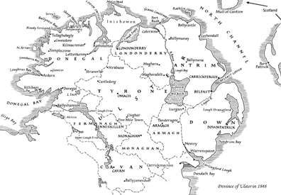
The Northern Ireland map below shows the province of Ulster as it was in 1848, at the height of the famine that brought unbearable suffering to millions of people.
Death and emigration caused the population to shrink dramatically. Some counties, especially the more rural, have a considerably smaller population density in the 21st century than they did in 1841.
Even allowing for later migration to cities, the figures tell the tale of a devastated population.
The province of Ulster
In 1922, the island of Ireland was split into two entities. The process is usually referred to as 'Partition'. Six counties in the province of Ulster became a separate and distinct part of the United Kingdom - Northern Ireland - while the remaining 26 counties (including three from the province of Ulster) became what is now the Republic of Ireland. In the early years following partition, the 26 counties were referred to as the Irish Free State.
This is how the nine historical counties of Ulster were 'distributed':
- Republic of Ireland: Cavan, Donegal, Monaghan.
- Northern Ireland (UK): Antrim, Armagh, Down, Derry-Londonderry, Fermanagh, Tyrone.
When conducting Irish family history research it is important to make the distinction between the two political states because some records are held in Belfast and others in Dublin. Knowing in which state your ancestors' county now lies can save you valuable research time.
The population of Ulster in 2002 and 1841
| County | Area in KMs2 | Population 2002 |
Population 2002 per KM2 |
Population 1841 per KM2 |
| Antrim | 2844 | 566,400 | 199 | 125 |
| Armagh | 1254 | 127,700 | 102 | 185 |
| Derry | 2074 | 214,800 | 104 | 107 |
| Down | 2448 | 416,600 | 170 | 148 |
| Fermanagh | 1691 | 54,200 | 32 | 93 |
| Tyrone | 3155 | 161,800 | 51 | 99 |
| Cavan | 1931 | 56,416 | 29 | 126 |
| Donegal | 4841 | 137,383 | 28 | 62 |
| Monaghan | 1294 | 52,772 | 41 | 155 |
Source: All-island Census 1841/Census 2002.
2021: Northern Ireland's statistical office no longer collects data on a county basis, so the table above cannot be repeated with more up to date information. The latest population figures for Northern Ireland are from the 2021 census which counted 1,903,175 inhabitants.

