Richard Griffith's Valuation unlock the code
Learn the annotation code to uncover
the detail hidden within Griffith's Valuation of Tenements.
-
Home
›
-
Land & Property records
›
-
De-coding Griffith's Valuation
Richard Griffith's Valuation of Tenements is rich in detail but many, many genealogy researchers don't get to grips with its 'code' and, as a result, never really release all the information noted about their ancestors and the area where they lived.
Order of pages
Richard Griffith's Valuation was published one county at a time. Within each county, the Valuation of Tenements are arranged by Poor Law Union (PLU) and then by parish. The townlands of each parish are then listed alphabetically.
Using samples from across the island, this page will help you to take a fresh look at Richard Griffith's Valuation and the detail it holds.
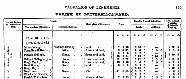
The townland of Boyoughter, Co Donegal
In this Donegal townland, the first two names, James Waugh and Cornelius McGeehan, are referenced with individual numbers (1 and 2 respectively), which means that their landholdings were identifiably separate.
They may, or may not, have been adjacent to one another.
The numbers relate to the plot numbers marked on the Valuation maps.
Land measurements
Richard Griffith's Valuation shows land measurements in English acres, roods and poles (or perches).
An English acre is 4840 sq yards.
A rood is a quarter of an acre ie 1210 sq yards, so four roods make one acre.
A pole or perch is 30 ¼ sq yards, so forty poles make one rood.
Both these men are renting from James Connolly, who seems to be the major landowner in these parts.
While Waugh rents only some land (just over seven acres), McGeehan rents both a house and land (a little over nine acres).
His house would be clearly indicated on the Valuation map.
Patrick McHugh is also renting land from Connolly.
His land has been assessed as having two different soil types, A and B (details of which would be explained in the Field Books that form part of the Richard Griffiths Valuation collection).
The two acres of A grade land is valued at seven shillings, while his ten acres of B land is valued at 13 shillings, reflecting its poorer quality.
Bridget Gallagher is noted as 'jun' meaning 'junior' which means there is another Bridget Gallagher, her mother, also living in Boyoughter.
The brackets that bind the three names at plot seven denote the terms of their lease. This is explained below (townland of Ballyfinegan)
The townland of Mill Street, Tullow, co Carlow
Entries for this county Carlow townland show a variety of descriptions of tenement.
Richard Griffith's manual of instruction, which was used by all his Valuers, defined two classes of building.
As you might expect, the term 'house' meant a building used as a permanent dwelling place.
That's simple enough, but the properties which the Valuers were assessing were not always what we, today, would classify as a house.
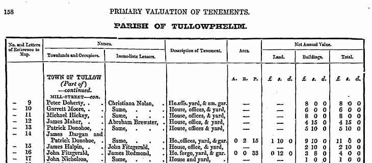
Within Richard Griffith's definition fell 'houses' as different as many-roomed stone-built mansions and single-roomed mud walled cabins.
Such fundamental differences were not noted in the Valuation; they are all recorded as houses, but the size and quality differences were reflected in the rateable values.
The other defined building type was the 'office'.
This term was used for farm outbuildings such as stables, cow barn, piggery etc, or even factories, mills and shops.
A forge (or smithy) was usually noted separately (as here at 16), as were all public buildings such as churches, schools and courthouses.
The townland of Colla, Co Cork
From the Valuation for the townland of Colla, near Schull on the fringes of Cork, it is clear that there is one large landowner. The 144 acres of plot 2 would, if managed by just one person, indicate a farmer of considerable local status.
On the next downward rung of the social ladder were small farmers who typically had between 5 and 30 acres of land.
Cottiers or labourers usually rented less than 5 acres.
In this example in Colla, the land is managed by ten farmers collectively (this arrangement is explained more fully in the example of Ballyfinegan below).
The land area may have been divided equally or it may not. There is no indication here of how the land was split, only the relative values of the houses nine of the lessees rented.
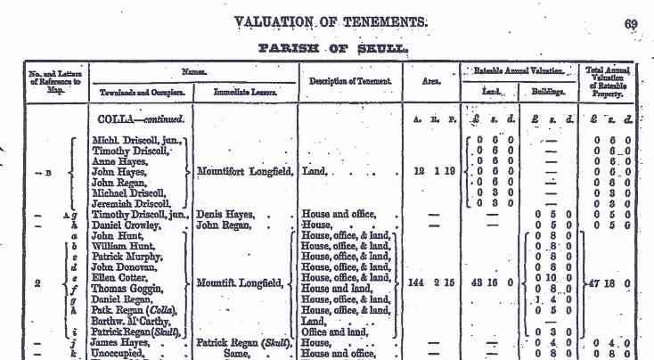
The lower case letters (a, b, c etc) in the first column relate to the houses identified on map of Plot 2 on the Valuation maps.
Daniel Regan, for example, lives in the 'best' house in Plot 2. If you study the corresponding map of the plot, you would find this house marked as 'g'.
You'll notice also that among the lessees of Plot 2 are two men called Patrick Regan.
The townland name of Colla has been typed in parenthesis after the first Patrick (Patk) Regan.
The townland name of Skull is recorded after the second Patrick Regan.
Richard Griffith expected his Valuators to provide additional information (agnomen) where two or more individuals in a townland shared the same name.
This, as anyone studying Irish genealogy soon discovers, is a regular occurrence in some areas.
While sometimes the agnomen merely helps to identify two different people, it sometimes provides direct genealogical information.
In this example for Colla, the agnomen identify the townlands where the two men live.
So while one Patrick Regan lives in Colla, on the land he rents, the other lives in Skull.
From an entry further down the list, it appears he sub-lets the house on his rented land to James Hayes.
The townland of Ballyfinegan, Co Roscommon
Ballyfinegan is a townland in the parish of Ballintober in the county of Roscommon. Richard Griffiths Valuation of Roscommon was published in 1857.
The first entry (1a) for Ballyfinegan shows Patrick Tighe renting an enormous estate of 160 acres of land, complete with his house, outbuildings and a herdsmen's house (probably little more than a shed or hut and a potato patch).
At 1b is Thomas Reddy, probably a labourer, renting a small dwelling and vegetable patch within Tighe's estate.
The land area of 1a and 1b are separated for valuation purposes, but would be within the same plot on the Valuation maps.
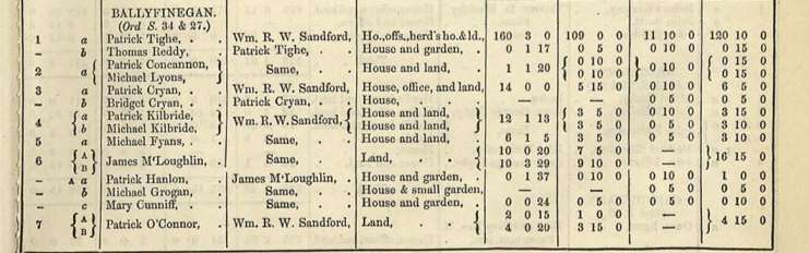
At no 4 there are two households (a and b) on a 12-acre plot.
Patrick and Micheal Kilbride reside in separate dwellings but they hold the land 'in common', as denoted by the brackets.
Under this 'in common' system, each occupier works his own part of the land but each tenant is financially responsible, along with all other tenants, for the full rent.
In this case, if Patrick Kilbridge fell ill and couldn't pay his share of the rent, Michael would have to pay both shares of the rent.
A similar arrangement applies to Patrick Concannon and Michael Lyons, although in their case they share one property and just over one acre of land.
Money values in mid-19th-Ireland
The currency in circulation was the pre-decimilised British Sterling ie Pounds (£), Shillings (s) and Pence (d).
Twelve pence (12d) equalled one shilling (1/- or 1s), and 20 shillings (20/- or 20s) equalled one pound.
ie £2-9-3d plus £2-11-9d = £5-1-0d.
James McLoughlin rents more than 20 acres of land in this townland. It has been assessed as having two soil types (A and B).
He also rents out three small houses and gardens to Patrick Hanlon, Michael Grogan and Mary Cunniff.
Note than Hanlon and Cunniff have a 'garden' on which they have to pay rates.
Grogan's small 'garden' is probably little more than a few rows of potato and cabbage plantings while Mary Cunniff's garden was a little over one-eighth of an acre.
These three households pay their rent to McLoughlin but this doesn't mean that he is the owner of the land. Only the immediate lessor is noted in Richard Griffith's Valuation.
A check of the surrounding townlands (not illustrated here) shows that McLoughlin rents a number of plots of land sprinkled across the parish, most of them from William Sandford who seems to be the dominant landowner of the area.
It appears, therefore, that McLoughlin is sub-letting some of the land he leases from Sandford.

See my personal selection of the very best free online databases for Irish genealogy research. Click image.
Where next?
← top of page
Images reproduced with the kind permission of the National Archives of Ireland